Chasing the Carrizo Plain Superbloom
A one-day adventure through California’s wildflower wonderland—with a simple itinerary to help you experience it too.
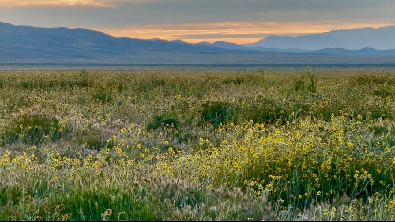
Spring is in the air in Southern California. It may not be official for another week or so but we are seeing it pop up all around us. On freeways, backyards, mountain, or hillsides, and valleys. If you live here, you know what I’m talking about. The wildflowers. Oh yes! The joy that springs up (pun intended), when seeing bits of yellow, orange, purple, white, and pink turn into carpets that look like a can of paint spilling down and across slopes and beds of the Californian landscape.
Blooms and superblooms become the buzzwords in casual conversations. Exchanging photos and social media posts of what’s blooming and where, are dopamine of the day this time of year. We’re hooked and need to satisfy the urge to witness these pageants of color.
Usually, my yearly wildflower trek takes me to Anza Borrego. A rugged desert floor that transforms into a colorful patchwork quilt in the Spring when rainfall has been decent. Though trust me when I say that even when blooms are sparse it’s worth the trip. Seeing any flowers makes you want to bend down and say, “Hey little guy, look at you! That’s right you just spread your little colorful smile to the world!” Anza Borrego will forever pull at my heart strings!


This past weekend brought Santa Anas to much of Southern California and if you don’t know what Santa Anas are, they are winds that come from the desert and are officially called Santa Ana Winds. It actually has nothing to do with wildflower blooms— although if severe enough, they could potentially damage tender petals and rapidly evaporate soil moisture, accelerating the end of the flowering season. However, the reason I bring it up is because anything that is reminder of the desert is a reminder to get out and see the wildflowers before they disappear so you better start making your plans. If you haven’t witnessed the superblooms, boy are you are in for a treat!
As soon as the tantalizing photos of blooms started trickling in my social media stream, it was time to make my plans and this year I really wanted to visit Carrizo Plain National Monument.


I did not know much about Carrizo Plains and it wasn’t until I read The Enduring Wild by Josh Jackson that I learned that they are part of the BLM (Bureau of Land Management). The book was a great way to be introduced to this area as well as other public lands overseen by the BLM. Josh writes of his experiences and on his first visit during which the Carrizo was experiencing severe drought. He describes, “The entire valley and surrounding hills took on the color of a hay bale.” In 2022 he returned and the transformation left him in disbelief stating, “Soda Lake Road had become a yellow brick road, and I had wandered into the Land of Oz.”
If you’ve ever read something that has moved you and you could take the opportunity to experience it yourself, this was my nudge to seize the moment when the words superblooms are humming in my brain.
It did not take me long to plan my weekend excursion. I knew I might be ahead of the peak, but that would hopefully keep me ahead of the crowds that have been known to flock to superbloom areas and in extreme circumstances they have even closed down, freeways, trails, and shut down parks altogether.
So it’s important to have your strategy. One, try to plan when it’s less likely for crowds to be there. Either plan your visit before peak but when there’s evidence of flowers blooming, or go on a weekday. I usually do the latter.
My husband had given away our tent. And in a moment of half listening, I apparently allowed that to happen. Big mistake. Anyways, I chose a refurbished motel (that to our delight, turned out to be nostalgic and swanky in an old California ambience sort of way) that was an hour and a half away from our destination.


Unbelievably, I didn’t see much in the way of lodging when I was researching. Oddly enough, I think this worked out best! It sort of broke up our trip and we were still able to get up for sunrise and arrive at the end of the long dirt road two minutes before the sun made its way over the Temblor Range.
Early mornings in the desert are chilly, especially this time of year. We were prepared and had dressed in layers.
The light began to illuminate on a dense field of flowers. Yellows and oranges are intertwined with purples, blues, and creamy whites vibrant against a dark blue sky that was turning its own mix of yellows, oranges, and purples as the sun breathed daylight into the firmament. The birds were already awake as they were singing at the top of their lungs. A joyful praise of sorts. We stretched our legs, walked along the dusty road and peered into the mass of blooms in wonderment. Orange and yellow fiddlenecks with their flirty twirls, white creamy lupines, the endangered California jewelflower with its little magenta bells burst at every nook and cranny of my site line.
After about an hour, we came back to the car and drove just a short distance to Wallace Creek. There’s a small dirt parking lot off the small dirt road known as Elkhorn Road. It offered a short trail. Naturally, we had to investigate it. This was fascinating. On top of the San Andreas Fault line a plaque explained how the land shifts every year closer to San Francisco. If you stood in exact spot for 10 million years, you would be in walking distance to the Golden Gate Bridge. Huh? With having no coffee, I was not about to figure that one out. Still, being able to see and experience this famous and mysterious fault line that has had such an impact on the whole state of California was pretty incredible.
Our next step was to Soda Lake which we could see from where we stood at Wallace Creek. The views were vast. In the intense layers of yellow upon yellow upon yellow really did resemble a yellow brick road.
Soda Lake is California’s largest remaining natural alkali wetland, this 3,000-acre shallow lake changes dramatically with the seasons. During dry periods it looks like a brilliant white salt pan, covered in natural mineral deposits, but in winter it fills with water and becomes a peaceful stopover for migrating birds and other desert wildlife. We arrived on the cusp of Spring. The lake still had water, but its edges had started to become crunchy salt patches that looks similar to snow. The flowers in this area had changed to low lying beds of tidy tips, and red-stem filagree intertwined with beds of goldfields and phacelia lacing the valley floor. All the while, the rolling Temblor range flanks the eastern side of the lake with its green grass with yellow and orange cascading down its hillsides. The dramatic Caliente Range sits to the West far enough away that it takes on a dark purple rugged backdrop to the silver blue hue of the lake.
We saw more people congregate to the lake as well as seeing cars having to turn around or being parked on the outskirts because the roads were too muddy for those who do not have an all wheel drive vehicle.
We continued on to Painted Rock. I really wanted to see this place because of the pictographs dating back 4,000 years. These pictographs were painted primarily by the Chumash people believed to come to this horseshoe-like rock for ceremonial purposes. It should also be mentioned that the Salinan and Yokuts made their contributions to these paintings. I hadn’t realized that I needed to secure reservations to be able to go and see this archaeological site and was trying last minute to see if I could purchase them online. However, I discovered that is not possible the day of visit. We went ahead and drove to the welcome center there anyways to see what information they might have. As luck would have it they do have tickets available there on first come first serve basis and we happened to be the last two tickets given out that day. We were instructed not to touch the rock or paintings, as the paintings were already deteriorating and the human touch would only exacerbate the deterioration. Also, we were asked to please not take pictures or videos of the sacred site intended for social media. We could, however photograph them for our personal memories.

Once granted, the gate code was given to us to drive up to the trail and do the self-guided tour. The trail is at most a flat mile to the rock. Lupines of purple, creamy white, and a mix there of they are practically holding hands with the desert fiddleneck as they waved to us in the breeze, happy to see us on our journey. Dainty spring gold biscuit root bright, yellow in color appeared like lace doilies at our feet and the shy magenta owls clover peeked out from underneath.
There were only a few people on the trail and most of them were already heading back to their cars. By the time we got to the Rock, which was 20 minutes at most, we had the place to ourselves. I was surprised at the intense, solemn emotion that was harboring in my chest in what I can only guess was in reverence of the people who once inhabited this place and considered it sacred. Moreover, the fact that the murals in many places had faded greatly but yet some appeared as if 1,000 years were like 10, was an eerie feeling. And they did seem from another world. We studied them for probably 20 minutes before deciding to head back. Bringing my photographs for me to look at and study more at a later date to see if I could make some sort of sense of the stories they were trying to tell.
We got in our car as the last people to leave The Rock that afternoon and drove back across the plains, past Soda Lake, past more varieties of flowers, yellows, purples, whites, oranges, some mingling and others keeping to their varietal colonies. We drove towards the range elated and tired. We decided to stop once more for our long awaited picnic. Since there are very few trees we pulled into a turnout that had several trees along an old wooden fence line. There was ample room for us to park with a view of Soda Lake to the East as we were nestled in the hills with all their pageantry of colors surrounding us. A perfect place for us to sit and have a picnic. My husband took a nap while I turned on my Merlin app since there were so many birds in song or calls- I do not know since they constantly were interrupting each other. As I ate my cookies, my app lit up with one bird appearing after the other as it registered each species. I could hardly keep track and certainly was not familiar with many of them. I took a screen recording so I could go back and learn a little more about those chatty creatures. I got my binoculars to see who was being the loudest, where I was seeing little darts of feathers and their coming and goings. Birds are fascinating. No wonder there are people dedicated to birding.
We packed up our picnic, took a few pictures, and headed back towards our charming hotel. We enjoyed all the switchbacks since it brought view after view of the hillsides. But soon enough, we were out of the range and into what looked like miles and miles of oil rigs. Some working but most not. Seemingly a wasteland of iron dinosaurs. Such a paradigm shift from the Carrizo. From nature to literally extracting nature. As I drive in a car that needs gas that may have come from the ground, where these rigs are drilling and if not from a rig somewhere else.


The Carrizo Plain reminds us that wild beauty exists for all who seek it out and take the time to enjoy it. It reminds us that each season has its purpose. For a few brief weeks each spring, the valley bursts into color, the birds fill the air with song, and the land tells a story that has been unfolding for thousands of years. The flowers will fade, the winds will return, and the hills will turn golden again, but the memory of standing there—surrounded by that fleeting pageant of life—becomes part of your own experience. And perhaps the places that connect us so deeply to nature are also the ones that guide us to protect them and return to them again.
If you’d like to see my post on Nature’s Playbook, it’s a free app where you’ll find not only my experiences in the Carrizo Plain, but also authentic stories from our members who love the outdoors. People share a wide variety of ways they connect with nature. We’ve also started a nature book club called The Atlas, which brings together literature, landscapes, and the ways we care for both.
I will drop in my itinerary if anyone is interested in visiting this remarkable land that is endowed to all Americans.


Carrizo Plain National Monument — One-Day Itinerary (Quick Planning Guide)
This streamlined itinerary focuses on what you need to know to plan your day in Carrizo Plain National Monument—where to stop, how long to allow, and helpful preparation tips.
Carrizo Plain is remote public land managed by the Bureau of Land Management (BLM), so planning ahead is important.
⸻
One-Day Carrizo Plain Itinerary
1. Sunrise Wildflower Stop (Temblor Range Area)
Location: GPS: 35.2380, -119.8000
Driving Directions: When turning left (east/southeast) onto Elkhorn Road from the northern end near Seven Mile Road / Highway 58, you’ll be traveling southeast toward the intersection with Calhoun Road inside Carrizo Plain National Monument. This road runs along the base of the Temblor Range, making it an excellent area for sunrise views and wildflowers.
Arrival Time: Plan to arrive 30 minutes before sunrise
Typical Wildflowers:
Desert Fiddleneck
Lupines
Goldfields
Purple Filaree
California Jewelflower
Important Tips:
Stay on existing roads or trails. Do not walk into flower fields.
Follow Leave No Trace Principles to help protect fragile wildflower areas.
Spring rattlesnake awareness: This habitat supports rattlesnakes. We did not see any, but it’s another reason not to wander off trail.
Early morning is often quiet and less crowded, with good bird activity.
Good For:
Sunrise viewing
Wildflower photography
Birdwatching
⸻
Distance: About 1.5 miles round trip
Time Needed: 45–60 minutes
What to Know:
One of the clearest visible examples of movement along the
San Andreas Fault
Mostly flat and easy walking
Wildflowers often line the trail in spring
There is very little shade, so bring water even for short hikes.
⸻
3. Soda Lake
Time Needed: 30–45 minutes
What to Expect:
Seasonal alkaline lake
Salt crust forms as water evaporates
Wide valley views
Wildflowers Often Seen:
Tidy Tips
Goldfields
Purple Filaree
The white ground near the lake may look like snow, but it is actually salt left behind as water evaporates.
⸻
4. Painted Rock
Time Needed: 20–30 minutes
Important Notes:
Ancient Indigenous pictographs estimated 3,000–4,000 years old
Cultural site used by Chumash and Yokuts peoples
Respect Guidelines:
Stay on designated paths
Do not touch the rock art
Visitors are asked not to share photos of the pictographs on social media
⸻
You can find roadside pullouts throughout the plain that make great picnic spots.
Look for:
Pullouts with a few shade trees
Views toward Soda Lake or surrounding hills
Quiet roadside areas
Birdwatching can be excellent here. A helpful tool is the Merlin Bird ID app, which identifies birds by sound.
Common birds in the area include:
Western Meadowlark
California Quail
Loggerhead Shrike
Red-winged Blackbird
Common Raven
Goldfinches
Sparrows
⸻
Preparation Tips
Vehicle
4WD or high-clearance recommended
Dirt roads can become muddy and rutted after rain
Some visitors may need to turn around if vehicles cannot pass
Bring
Plenty of water
Snacks or picnic lunch
Hat and sunglasses
Reef-safe sunscreen
Comfortable walking shoes
Layers (mornings can be 40s°F, afternoons 80°F+)
Connectivity
Cell service is very limited
Occasionally a few bars appear along main roads
Bathrooms are available at:
The Carrizo Plain Visitor Center
The Painted Rock Welcome Center
⸻
Best Time to Visit
Wildflowers: March–April (depends on rainfall)
Bird activity: Early morning and late afternoon
Superblooms happen only in years when winter rain triggers the seed banks stored in the soil, allowing large numbers of wildflowers to bloom at once.
⸻
Helpful Planning Links
BLM Carrizo Plain Information
https://www.blm.gov/visit/carrizo-plain-national-monument
Wildflower Updates
https://www.blm.gov/programs/national-conservation-lands/california/carrizo-plain-national-monument
Nature’s Playbook App (free)
The Atlas Book Club
Book, The Enduring Wild by Josh Jackson
https://www.forgottenlandsproject.com/the-book
Merlin Bird ID App
https://merlin.allaboutbirds.org/
Lodging: Cuyama Buckhorn Roadside Resort | High Desert Hideaway, New Cuyama
Reservation for Painted Rock Tour
Painted Rock Self Guided Tour, Carrizo Plain National Monument Tours - Recreation.gov


